Normally, I just read things, learn, and condense it for you folks on the blog. Here, however, the US Bureau of Reclamation (the dam's owner) has a bit on their website that's worth reading, so I've pasted some below. On their website are several videos that are also worth your time to watch.
"The Columbia Basin Project, which includes Grand Coulee Dam as its main feature, is the Bureau of Reclamation's largest multipurpose project. Grand Coulee Dam includes three major hydroelectric power generating plants and a pump generating plant. The facilities provide power generation, irrigation, flood control, stream flow regulation for fish migration, navigation, and recreation.
Power production facilities at Grand Coulee Dam are among the largest in the world; the total generating capacity is rated at 6,809 megawatts. Average yearly power production is 21 billion kWh with power distributed to Washington, Oregon, Idaho, Montana, California, Wyoming, Colorado, New Mexico, Nevada, Utah and Arizona. In addition, Canada receives power under the Columbia River Treaty. Grand Coulee Dam is operated as part of a coordinated federal system of hydroelectric facilities, which provides 75% of the entire power supply of the Pacific Northwest.
In addition, Grand Coulee Dam funds a complex of three hatcheries (Leavenworth, Winthrop and Entiat), collectively known as the Leavenworth Complex, to mitigate for the loss of anadromous fish above the dam. Over 2 million spring Chinook and summer Steelhead are raised annually.
Authorized under the National Industrial Recovery Act and later by the Rivers and Harbors Act, Grand Coulee Dam and Left Powerplant were constructed between 1933 and 1941. The Columbia Basin Project Act of 1943, based on extensive studies known as the Columbia Basin Joint Investigations, authorized construction of the Columbia Basin Project, which consists of 330 miles of major distribution canals, lakes and reservoirs, and about 2,000 miles of laterals that currently irrigate approximately 670,000 acres of land.
The economic values of the Columbia Basin Project include irrigated crops valued at $1 billion annually, hydropower production of approximately $1.2 billion annually, and the prevention of more than $206 million in flood damages since 1950. The Columbia Basin Project also resulted in the creation of vast wetlands and riparian areas, and provides recreation benefits to about four million visitors each year.
This project made the development of the Pacific Northwest possible and its importance to the nation has been profound. Its influence spread outward to benefit all citizens. Construction of Grand Coulee Dam put thousands to work during the Depression. Grand Coulee's generators played a vital role in supplying power to build planes, ships, tanks and develop atomic energy during World War II. Following the war, the Columbia Basin Project provided opportunities for returning veterans to farm their own tracts of land. With the completion of the Third Power Plant in 1980, Grand Coulee's status as the largest hydropower generating facility in the United States was assured, and tangible benefits to Canadian residents were realized.
The importance and significance of Grand Coulee Dam and the Columbia Basin Project continue to be realized today."
Here's what we saw when we visited the dam.
This is a picture from one of the kiosks showing an aerial image before the dam went in. Notice, no dam, no towns, no bridge, not much of anything but high desert.

We stopped upstream of the dam. You can see the Roosevelt Lake impounded. The lake is 151 miles long (that's from Albany to Boston) and holds a little more than 9 million acre-feet of water. The line across is called a buoyline, and is a cable with floats intended to keep boaters and debris out of the dam. Notice how the sections curve inward, because the current is pulling the line to the left, or downstream toward the dam.

This is looking across the lake to the other side. Notice that there's lots of shore showing. This is because they've drawn the lake surface level down, so there's more space to hold spring water from snow melt and spring rains. Remember, one of the specified uses of the dam is flood control. Its always funny to me that even with all this water THAT CLOSE, trees don't grow up on the hill near the river. The region is just too dry, and the soil is too thin.


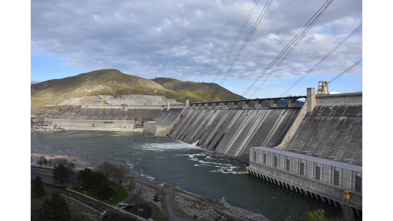
From the same place looking downstream toward the dam. The left bit you see is the spillway, where excess water is passed over the dam. The kinda dark bit to the middle right is the intakes for the right powerhouse. This dam has a left powerhouse, a right powerhouse, and the other powerhouse (that is really what they are officially called).

Here, you can see the black screens over the intakes to the turbines. This is the left powerhouse. The turbines here are 150,000-165,000 horsepower each and each generator generates 125 MW.

A better view of the upstream side of the spillways. I've actually never seen this design before. This spill way is controlled by what's called a drum gate. The gates drop to let water through. They're each 130 feet long and 30 feet high. I.e., it's about 130 feet between each of these arches you see in this picture. This particular dam is BIG and has no fish passage. So, there's no reason to spill unless they have too much water coming down the river, and if they do spill, they are wasting water that would have generated electricity. So, they pretty much don't.

Intakes to the right powerhouse. The turbines here are 165,000 horsepower each and generate 125 MW each.

Pumped storage is something many folks have never heard about. The idea is that during periods when people don't use much electricity (night-time and weekends), there is extra water (electricity) to spare. Instead of wasting it, they use the generators as giant electric motors and the turbines as giant pumps to pump water about 300 feet up to another reservoir. Then, during periods of peak need, like early in the day when everyone gets up and cuts on their appliances and heaters, or mid-day when folks turn on their air conditioners, they can run these turbines conventionally and use the generators to make extra power. That's called pumped-storage. Here, there's a twist. They also use the water way high up in the reservoir to irrigate different regions, and fulfill their mission to "reclaim" land. Here's a schematic of the operation:

Here you see the intakes to the pumped storage / irrigation portion. The turbines are about 70,000 horsepower and pump about 1,600 cfs of water up. In generation mode, each of the twelve units generates about 50 MW of power. I.e., each of these 12 units has as much power as the biomass plant that was proposed for Russell a few years ago.

Here's one of the pump turbines. It's about 15 feet in diameter, I guess.

You can see the vanes on the inside. This is by a playground and kids play on it. There's a ladder to the left to get in and out of it.

Here are the 12 pipes from the 12 pumps, going up the mountain to the lake. There's a good aerial view of this in the videos linked to above.

This view is from downstream, looking at the left side of the dam. This is the left powerhouse. To the left of the picture, you can see the downstream face of the spillway. The dam is 5,223 feet long and 550 feet high. As you can imagine, my pictures don't begin to give you an idea of the scale of the thing.

Here, you can see the left powerhouse (near), the right powerhouse on the far side of the spillway (which is releasing a "tiny" spray of water), and on the far side of the river and left side of the picture, something called "the third power plant." It's kinda like on that old Bob Newhart show, where the guy would introduce himself as Larry and his brother Daryl and his other brother Daryl. Here, it's the left one, the right one, and the other one :-)
Closer view of the right one. Notice that the water is moving, but calm downstream. As discussed in the Bonneville post, the potential energy of the 400+ feet of head pressure on the water has been converted into electricity, and there is little kinetic energy left in the water.

Here's where it gets really unusual. They realized that they had more water than they could generate with, so they blasted out a bit of the mountain and made a whole other powerhouse, the "third powerhouse." This was completed in 1980. Here's a view of the forebay (lake upstream) you can see the black trash racks on the dam to the right which prevent logs and the like from going into the turbines. On the other side of this bit of the dam are the tunnel arches.

This is a really unusual design I've never seen before. Those vertical arches are actually giant concrete pipes or tunnels that the water flows through and into the powerhouse below. This one is a WHOPPER.

It has 3 turbines that are 820,000 horsepower generating 600 MW and 3 turbines that are 1,053,900 horsepower generating 805 MW. That's an INSANE amount of electricity. As a power comparison, a Prius has 121 HP, so the "other" powerhouse has the same power as about 46,000 Prius's. A BIG locomotive has about 6,000 horsepower. So this "other" powerhouse has the power of about 312 locomotives. Remember the car carrier ship you saw in the Columbia Bar blog post? That has just 18,000 horsepower. The "other" power house has as much power as about 100 of these ships.
And...there's still the right, left, and pumped storage powerhouses! All together, this one dam powers 2.3 MILLION households!
There are tiny holes used to pass a leeetle bit of water. Each hole is 8 1/2 feet in diameter - big enough to drive a van or truck into.


We walked through the town of Coulee City and found a high degree of civic pride.

There were a lot of photos on the bridge below the dam that are worth sharing with you. Here's the river before the dam.

Here's the river after the dam, along with the dam. This is a later picture which has the "other" powerhouse on the left side of the picture, so it's after 1980.

Here's them blasting to put that third powerhouse in. If you look, you can see the temporary coffer dam installed on the left side of the picture. This allows them to work in the dry on the new part of the dam. The cofferdam is then removed when the work is done.

People always wonder how dams are built. This is a good picture showing the base of the dam half built. The left side (right on the photo) is done, and water is passing through it. The right side (left of picture) is undergoing construction and is made dry by putting in a temporary cofferdam. After the right side is done, they'll remove this cofferdam and build on upward. There would have been a coffer dam protecting the left side of the dam earlier, but once they got that base built, they removed it. I imagine they just reused the rock and materials on the right side.

Here's a great picture of the spillway under construction. You might remember the discussion in the Bonneville Dam post about issues with the water downstream of the spillway having too much energy. If the water flows too rapidly, it can erode the bottom and sides of the river channel downstream. There are different methods to prevent this. Here, they have made a giant flip lip below the spillway. This is underwater during normal flows, and you can no longer see it. But, if they spill water from the dam, this curvy bit will flip the water back, making a giant breaking wave and dispersing the kinetic energy of the falling water. Really cool. The caption below the picture said to look for the two workers on the lower right for scale, but I could never see them, unless they are the two dark dots? Realize that you're looking at a 450 foot high wall!

Here's a job you might not have thought about...

And this VERY dangerous one, sitting on a board seat from a rope with an air powered jack hammer, to loosen rocks from the canyon wall and prepare it for the concrete.

Here, you can see one place where those guys jack hammered, and see the anchor bolts in the rock that keep it from falling. This road is near where I took the first pictures for this post. Note the full-sized pickup for scale.

This excavator was a big deal back then, but it's tiny compared to those we saw excavating in the Mission Mine blog post.

Workers waiting to be paid on Friday.

The Bureau had to build houses for the workers, and towns to supply their needs. Remember from the first photograph of the blog, previously, there was nothing here. It is the middle of the high desert.

While I was driving around taking these pictures, the security guard (by white truck) was getting nervous. The security at all the dams we visited is MUCH higher than it was before 9/11.

If you're president, you get credit for things that happen while you're in office. A bust of F.D. Roosevelt, who they named the lake after.

77 workers died during construction, but their legacy is that this dam is still producing power and irrigating the crops that we eat in MA, some 2,500 miles away.
No comments:
Post a Comment