We took the opportunity to wander over to the Bonneville Dam and Powerhouse, in Cascade Locks, Oregon. This is the furthest downstream dam on the Columbia River. The project is owned by the US Army Corps of Engineers, and this was one of the dams I worked at during the 7+ years I worked as a contractor for the USACE. My work focused on remediating the impacts of dams on aquatic ecosystems and environmental data analysis. This is a really long post, because I thought it would be informative to tell you about the problem, our work, and the environmental remediation.
Like most dams, this one is multi-purpose. Primarily, it provides power and aids navigation, but it is also used for flood control, fisheries habitat, and recreation. The facts and a few historic images in this posting are from Kiosks at the visitor's center and from the USACE web materials. Here are some interesting facts about the Columbia River.
- One half the nation's hydroelectric power is generated on the Columbia River
- 3/4 of the region's electricity is from the Columbia River
- Water from the river irrigates 7,000,000 acres of land in five states
- Using the lock and dam system, Lewiston, Idaho is a port for ocean going vessels - 431 miles inland and 738 feet above sea level
- More than 7 1/2 million tons of cargo pass through the system each year
Here's the map. Notice that there are two powerhouses, and that the spillway is in the middle. The powerhouses are just what the name implies, places where there are turbines that spin generators that make electricity. The spillway is used to pass excess water past the dam, or to augment flows to help fish migrate downstream. At the bottom of the map, you can see the navigation lock, which raises barges up over the dam. Unfortunately all the locks on the system were shut down the week we were here, for scheduled annual maintenance.

| 1st powerhouse length | 1027 ft | 313 m |
| Generators/total output | ten | 660 mw |
| 2nd powerhouse length | 986 ft | 300.5 m |
| Generators/total output | eight | 558 mw |
Bonneville navigation
| Spillway length | 1,450 ft | 442 m |
| -gates | 18 | |
| -reservoir above downstream side | 60 ft | 18.3 m |
| Navigation lock length | 676 ft | 206 m |
| -width | 85 ft | 25.9 m |
| Max. lift | 90 ft | 27.4 m |
| Avg. transit time | 30 min. |
*National Geodetic Vertical Datum
(Mean Sea Level)
This image shows how the dam works. The upstream lake bit is on the right, the downstream river part is on the left. In a nut shell, the dam backs the water up, which increases in elevation and stores potential energy. The water comes through the intake penstock, through some control gates called "wicket gates," drops through the turbine, and goes out the draft tube into the tailrace area. The potential energy is turned into kinetic energy as the turbine (propeller) spins. The turbine turns the generator up above, which passes magnets through a field of coils, making electricity. Then the high tension lines pass this electricity onto the power grid.

To give you an idea of size, here's the old turbine. If you've been reading the blog, you saw the flat Francis Runner turbine at Fontana Dam in NC that looked like a donut. This one is a variable pitched propeller. Imagine this spinning at 75 rpm, or one and a quarter turns every second.

They replaced it, but here were some unusually cool facts about this particular turbine.

And a picture of folks hanging out on the turbine as they install it.

Apparently, over the 60 years of service, the metal of the turbine fatigued, and they replaced it with a new minimum gap turbine which is supposed to be more efficient. Because the pitch of the blades is variable, they can also open them up to aid passing downstream migrating fish through without cutting them up.

Here's an important picture. This is downstream of the powerhouse. Notice that the water is flowing, but relatively calm. The potential energy of being high up was converted into electricity, and this water has little potential and kinetic energy, comparatively speaking.

It was just done raining, still with a few mountain clouds, but you can see that the area around the dam and Columbia River Gorge is drop dead gorge-ous (ha ha, get it?).

Looking across to the Washington side you can see the mountain(s) that created the Bridge of the Gods, from an earlier post.

This show's the relative distances and gains in elevation as river traffic passes through the lock and dam system up the Columbia and Snake Rivers. Lewiston, Idaho is a ocean port, 431 miles from the ocean!


These two hard to see photos show the navigation lock wall from the upstream side. The bit of water there is going into the first powerhouse (toward the Oregon side, in your handy map above).


This view shows the fish ladder. Fish ladders are concrete troughs with a series of barriers that migrating adults jump over, around, or through to work their way up over the dam. A fisheries biologist friend of mine said he tracked a fish going up one of the fish ladders at another dam, and that it took about 8 hours for the fish to make it up....and then it promptly fell down the spillway and back to the bottom.

Schematic of fish going up. Each of these drops is about a foot to a foot and a half high.

View from downstream looking up the combined fish ladder. This is not a migrating season, so we didn't see any fish going up.

Fish ladders came from both the spillway and the powerhouse to the combined spillway, which allows biologists to count all the fish that migrate.

Here's the junction looking down the fish ladder. The ladder from the first powerhouse is to the left, the ladder from the spillway is to the right.

Q. What does a migrating fish say when he hits the dam?
A. DAMN.
Actually, fish instinctively start swimming from side to side till they find a way upstream that they can make. Managers release water called fish attractant water near the opening to the fish ladder. This water is fast, but not violent like the spillways. That's the water on the right of the picture.

View looking down the spillway ladder to the mouth of it. Fish will swim right up this.

So, here's the spillway. It's spring and there's a lot of water in the river, so this is open to pass the excess water (water that can't be used for generation because the turbines are already wide-open) downstream. What's cool, is that you can see the results of my labor :-)
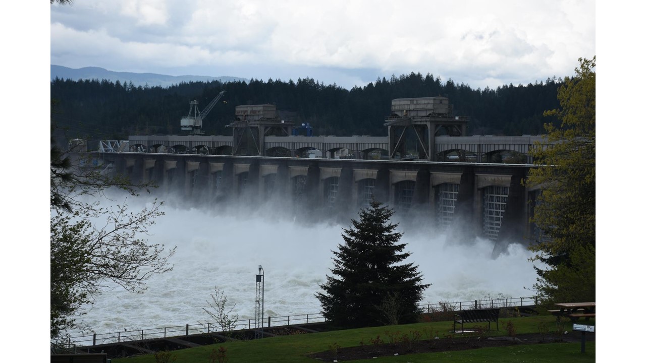
First, notice how violent and rapid this water. Here, the potential energy of the stored water wasn't turned into electrical energy, so it comes out as kinetic energy - the water is violently rocking and rolling! Realize that the concrete of the dam is about 125 feet high, and the river is about 50 feet deep here.

You can see that the downstream bit....

And the way downstream bit have a lot of kinetic energy.

Fish seem to like this fast water, and apparently fishermen do too. This fishing pier had rod holders cemented into it.

The problem we worked on here was one called Total Dissolved Gas. The gist of it is that you have water falling (like a water fall). As it does, it entrains air. The water passing through the gate (like your faucet) is solid and green, but by the time it falls, it has about doubled in volume like your faucet's water) and is half water and half gas. Because the water on the downstream side of the dam is deep (40-60 feet), the inertia of the falling gassy water drives it deep down, where the pressure is high (like when you swim to the bottom of the pool and your ears pop). The gas dissolves into the water at this high pressure.
If the gassed water stays deep, the gas is in equilibrium and just hangs out in the water. If that parcel of water comes up toward the surface, the pressure is less and the gas becomes super saturated, and bubbles out of the water. This is analogous to a can of soda...when it isn't popped open, the gas in the liquid is in equilibrium with the gas in the space between the liquid and the top. When you pop the can open, the gas in the can is super-saturated in relation to the atmosphere, and the gas bubbles out of the soda, until the soda is flat - in equilibrium with the atmosphere. In the downstream water at the dam, you can see and hear the gas fizzing out of the water, especially on an aluminum hulled boat.
The environmental problem is that any fish swimming down deep will get the gas in their bodies at a high concentration, and then if they swim toward the surface too quickly, they get gas bubble trauma disease. In my classes, I show pictures of this - distended swim bladders on juvenile fish, bubbles in the skin, bloody gills, and "pop-eye." It's pretty graphic. To prevent this, the EPA regulates total dissolved gas concentrations to 110% of equilibrium saturation. Our team of water quality monitoring folks set out to measure the gas at the sharp end of this stick, i.e., right in the giant waves, to see if the USACE was in compliance, or just how bad off things were.
At the time, we were the first and only team in the country to do this, and the techniques we developed were cutting edge. Most of the gas monitoring equipment we used was prototype equipment that a couple different companies developed just for us to use on this study. We deployed monitoring equipment to measure and record TDG. Because the water is so violent, they were deployed in 3-foot long 4" steel pipes which had 3" solid square steel bars welded on the sides. Each of these weighed about 200 pounds and was lowered to the bottom on cables which had buoys on the surface, so we could retrieve the instruments after the study.
To make the long story shorter, using Ice Harbor Dam as a study area (its the 4th dam upstream of Bonneville), we learned that the gas concentrations were as high as about 155%, well in exceedance of the EPA values. The USACE considered many options for remediation, and decided to try something called a deflector, which is essentially a huge horizontal steel shelf. The idea was that the falling water would hit the shelf, "bounce" off, and leave the dam horizontally, instead of going deep where the high pressure water was.
One was installed at each of the spill bays at Ice Harbor. Using the same monitoring technique, we measured the gas concentration before and after installation of the deflectors, and found that the concentration was reduced to about 119% - a dramatic improvement. Managers used the data we collected to make their decision. The USACE cut a deal with the EPA to get a variance by installing the deflectors on all 8 USACE dams on the Columbia and Snake Rivers. We got the job of measuring TDG before and after on every project. All together, this cost something like $400,000,000. So, kind of cool to see this spillway, with the water shooting out horizontally, instead of making a giant rolling wave, and helping protect the fish and improve the aquatic ecosystem - all based on the data our team collected. Unfortunately, there was no plaque with my picture on it.

Imagine sampling water in this area.

This violent area was full of life, though. Here's an osprey that caught one of the fishes.

Out here I saw a sea lion fishing right in the middle. It looked like a teenager getting into trouble. As you can see by this amazing photograph of him, he was VERY fast catching a breath and going back under :-) Its a tough management problem when protected species eat protected species.
This picture also shows the craziest thing in the world. There were a lot of seagulls fishing. See the fellow in the orange vest by the pickup truck? His job is to shoot off those whistling bottle rockets to scare the seagulls off the concrete wall so they don't just hang around eating the baby salmon. Fact is stranger than fiction.

No comments:
Post a Comment