This is one part of the states I never traveled to before, so it was really cool to see totally new things. We rode a ferry across the Mississippi, and while the ferryman was speaking English, it was next to impossible for me to understand his Cajun accent, or for him to understand me. This is as close to being in a foreign country as I've been in the US.
As you probably know, this area was flattened by hurricane Katrina in 2005, and it was interesting to see the progress in rebuilding. Most of the media and attention on the hurricane focused on the impact at New Orleans. I think that's because there's more people more densely settled, but also because there's more money there. However, St Bernard Parish was the epicenter of the storm, and even almost twelve years later a lot of the damage is still evident.
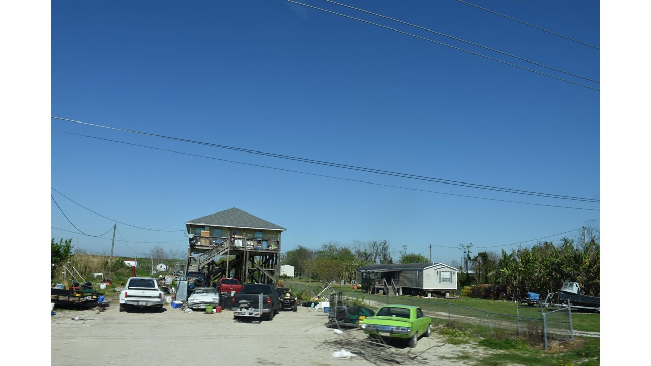
Out here, what I see are just hard-working middle-low income folks. You just don't see anyone sitting idle. Everyone seems to be doing something, building something, serving something, fishing for something. It feels like an area where people survive by keeping busy.
I'm didn't know what to expect here. We're camped at St. Bernard State Park, a quiet nature-filled campground, surprisingly just a few miles from some of the heavy petroleum industry refineries. While there are some tourists at the campground, many of the campers seem to be folks staying while they work at a nearby carnival. In general, we haven't seen much of anything in the area directed toward tourism. This is a working area.
As an environmental person, I guess I'm not a fan of the big petroleum companies, but like everyone else, I do use gas (a lot on this trip), and refineries need to be somewhere. This is probably as good as any place else, and a lot better than some places. We noticed that at these colossal refineries, the adjacent housing was arranged by wealth. Each refinery seems to have a ring of single-wide trailers around it, then a ring of double-wide "modular" homes, then duplex / rental housing, and finally a ring of single family homes. I guess if you can afford it, you don't live near the refineries. It was interesting to me that even with the millions and millions of gallons of petroleum products these refineries have stored, you can't really smell it. The can of WD-40 in the camper smells more than the refineries do.
We drove by several very large parking lots adjacent to helicopter ports, where oil rig workers leave their cars and fly out to the oil rigs to work. Huge ocean going ships are tied up to the sides of the levees, loading and unloading things, and there are a couple huge Navy supply ships tied up nearby.
We made a trip all the way down the delta to the tip of Louisiana, where the road literally ends. We began by taking a ferry across the river, and drove down the west side till the road ended. Then we came up, crossed to the east side on a second ferry, and came back to our campground. The round trip was about 130 miles.
All along the route, the land was protected from flooding by the river with levees on the riverside, and protected from flooding by the gulf by levees on the gulf side. So, in effect, we were driving on narrow strips of land a mile or so across, in a valley formed by the two levees. These pics will show you what we saw.

Notice that the right side is armored with concrete, to protect it from eroding by the Mississippi River, which is to the right. All these miles and miles and miles of dikes are constantly mowed to prevent trees from growing. Tree roots make tunnels where water can quickly erode the dike.

Anytime a road or railroad cuts through the dike, there is an enormous sliding gate that's closed during floods. This one is about 20 feet high.

One of the many refineries.

The storage tanks for this one went on and on.

Huge ships tied up to the levee were a common sight, and a weird juxtaposition against the green fields.

This is an enormous grain loading facility.

A mountain of coal waiting to be loaded, or just unloaded - not sure which.

On the other side of the road were green fields with cattle. A mile or so away was another levee.

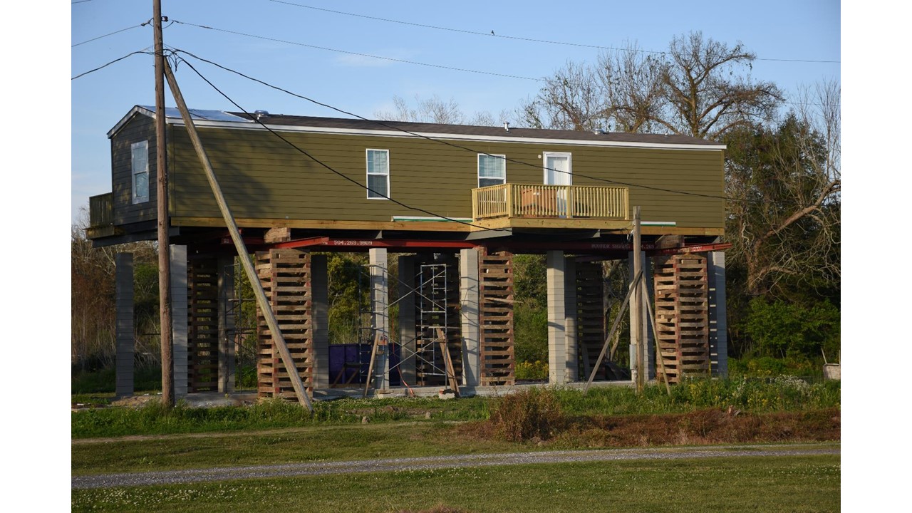
Most new construction was built up on stilts, after being wiped out by the hurricane and flooding due to the levees breaking.

This is the end of the road. Literally.

There was a wetland near the end, with pelicans resting in the trees.


Roseate Spoonbills in trees.

There's an enormous wildlife refuge, but its only accessible by boat.


We saw a lot of this. Houses on stilts, and mobile homes. We didn't see any built houses on the ground, and few built houses at all. Just about everyone lives in some sort of mobile home. Maybe 1 /100 homes looked like something old enough to have survived the hurricane.

The Mississippi and the levee

The new schools were all built up on stilts.

We saw a good number of homes like this one, that were never rebuilt after the hurricane.

As you may know, because of the high water table people in this area typically bury their dead above ground. We stopped at a small rural cemetery and happened to meet a local lady who is the head of the cemetery association. She explained that Katrina destroyed a lot of the crypts, and that many people do not have the money to rebuild. It was really quite heartbreaking to see the condition. These are not fancy vaults, but rather build from concrete blocks with some modest plaque and very little decoration.


Houses are built up on treated timbers or cement blocks.


These are the pipes from a pumping station, where water is drained and pumped out of the protected area. A reminder that the whole trip was made in an area that's below the river level.

We saw a good number of houses that were still abandoned.

A nice old traditional house nestled in the live oaks.

While nearby, a boarded up house that's been empty for 12 years.

Here's the cribbing where they've raised a trailer up to build the concrete posts under it. The posts look to be built with chimney blocks. When the blocks are dry, the trailer will be lowered unto them, and the wooden cribbing removed. Then the trailer gets strapped down to the posts. I wouldn't want to be up there in a heavy wind.
Here's another. Don't guess you'd want to jump out the window...

All in all, quite an eye opener and view onto a different way of living your life.
You were right where I was over winter break visiting family. A couple followups. South of NO, a lot of the damage to homes that you saw was caused by hurricane/tropical storm Isaac, in 2012. That 20 foot tall storm protection wall trapped alot of the surge south of NO, and the levees also held the water in so that area was basically a big tub where the water coming from the east had no where to go. Places that survived Katrina were inundated by the effects of the structures put up after Katrina to protect NO. Some of the cuts in the levees you saw are allowing river water to go back where it used to go and slowly create more land in the delta. As you went south you drove by that BP refinery on the west bank of the river, it was the last new refinery built in the US, in 1971.
ReplyDeleteIts a scary thought thinking about what these people went through and lost during not only Hurricane Katrina but all the tropical storms that have increased in strength and frequency because of climate change, its like they know every storm they deal with could be worse than the last. However it is good seeing that communities in the area are taking the proper precaution's in these situations with the 20 ft wall and leevs all working to keep and re-direct all the flood water to one specific area, that not only protects people but the natural sensitive environment's located there. But, they should make sure that these measures that help people also don't get in their way of living in the area especially those that survived from Hurricane Katrina.
ReplyDelete