
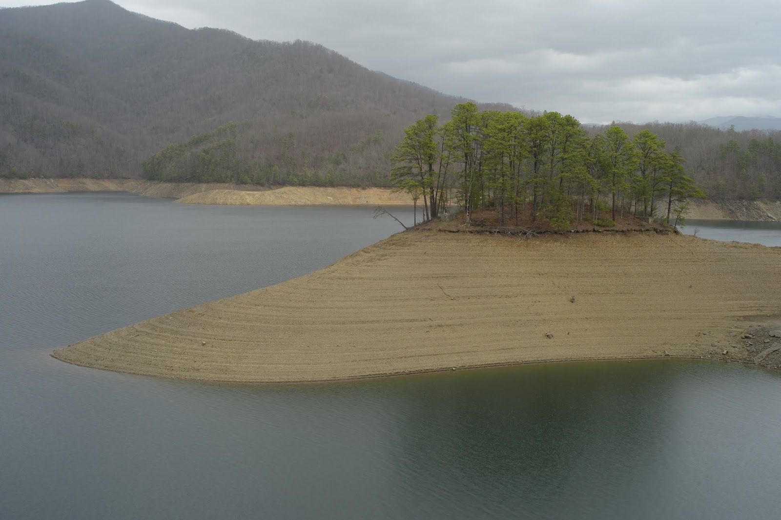
This is Fontana Lake. The Nantahala, Tuckaseegie, Little Tennessee, and Oconoluftee Rivers all flow into this lake. So, 4 rivers about the size of the Westfield River make this lake, which is at the base of the Smoky Mountains. I worked as a contractor for the US Army Corps of Engineers for a bit over seven years monitoring the impacts of dams and helping remediate their impacts on the environment.


This particular one is owned by TVA and like most reservoirs is what's called a multi-purpose project. The dam generates electricity, the reservoir provides flood control, it acts as a water supply, provides recreation, and habitat for wildlife. In this picture, you can see how the water level has been drawn down for winter and spring. As snows melt and the spring rains come, the reservoir water level will come up, but the potentially flooding water is not passed downstream. The water level fluctuates about 50 feet each year.
Here's Fontana Dam, which was built between 1942 and 1945 as part of the war effort. This dam is a whopper, at 480 feet high. Students in my water resources class will tell you that this type of dam is:
a. Apple Pie
b. Subaru
c. Concrete gravity dam
d. Eskimo pie
(Hint: Correct answer is c. I can't figure why students always do well on my multiple choice tests)

You get a feeling for the height when you're on top looking down...and an irresistible urge to drop a basket ball.

Looking downstream at the tailrace (Little Tennessee River). On the left you can just see the concrete structure which is a flip-lip for the spillways. On the right you can just make out a rusty looking donut, which is the turbine (a Francis Runner, I believe). This particular dam has 3 turbines and according to the kiosk, generates about 285,000 kw. The average home uses a little over 1kw of electricity. In this picture, they're not generating, and we say "the water is off."

This particular dam has two tunnel spillways that pass water over the dam during periods of high water when the lake is full. This keeps the water from overtopping the dam, eroding the structure and damaging it. These tunnel spillways aren't very common in the east. I guess this is about 75 feet in diameter, and it falls around 400 feet to that flip-lip in the previous picture. The purpose of the flip-lip is to redirect the energy of the falling water, so it doesn't erode the banks of the river. According to the kiosk, when water is spilling, the stream / spray extends up about 150 feet, and out about 400 feet...or, up a half-football field high, and out a football field and a half. I haven't seen it at this dam, but I have seen it at the next dam over, a dam called Cheoah. Cheoah had the worlds largest open overflow, meaning that when water spilled, it just came right down the concrete face...225 feet. It was really spectacular to see it (and a great day of whitewater boating)!

Here's the tainter gate that controls the water flow into that tunnel. You can see the grey winches on top that raise and lower the gate. This gate is around 30-40 feet wide, I guess.

In this picture you can see the massive hinges that the tainter gate pivots on....

Just in case you are wondering who built the dam. And in the background, a Southern Mountain Storm coming. Thunder. Lightning. And then it hit.

There's no way to say this without sounding snotty, but rain storms in New England just are not like this. These Southern Mountain storms are born in the Gulf. They go to school, learn the basics of storming, practice storming as they work their way across Texas, Mississippi, Alabama, Tennessee, and when they get to the Smokies, they're really something. They are full grown, experienced adult mountain storms with attitude. It's like water pouring out of a boot...
Here's the drive up to New Found Gap in the Smokey Mountain National Parks, wipers on "high". The Smokey Mountain National Park is the most visited National Park in the nation (today not so much).

At New Found gap, the road is at 5,046 feet. It's dumping rain, most of the drive up we were in the clouds and couldn't see more than about 100 feet. Decided not to go hiking this day.

Soaking, drenching, dumping, pouring rain...

And finally, later that day and back off the mountain, a picture of the Kudzu, an invasive with incredibly good smelling flowers. It was imported to prevent erosion, which I guess it does, but it takes over everything, covering up trees, telephone poles, and the like. Here in winter, it looks benign, but in the summer you wouldn't be able to see much but these vines. I believe they can grow as much as a meter in a day.

The storms getting an education was funny, I didn't know they're storms and overall rainfall was that much worse than what we deal with in the East. Cant imagine the amount of snow that falls in the winter, must be good for skiing. I also cant imagine what that much rain and snow does to the land that high, I'm sure mudslides are common.
ReplyDelete